The Urbanist wrote yesterday about the **insanely prescriptive kitchen-size standards**Seattle’s Department of Planning is proposing, and I intend to write something about that tomorrow. But while I was looking through the report I saw this map highlighting the locations of all 58 micro-housing projects in the city, overlayed onto a zoning map that shows all the land in the city that’s designated for housing denser than single-family:
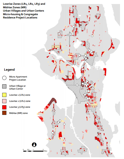
As the legend shows, if it’s colored in or shaded, you can build at greater than single-family home densities (though LR1 and LR2 are pretty low-density, too). Putting aside the issue of micro-housing and apodments, what I’d actually like you to draw your attention to is everything that’s not colored or shaded—all the grey on that map. That’s Single-Family Seattle*. That’s the part of the city where most people own their homes, and where residents could actually financially benefit from the property value-increasing development necessary to keep Seattle affordable. It’s also the part of the city that’s off-limits to essentially any new residential construction because preserving single-family “character” is so important. And it’s why residents in the remaining 20% of the city can barely afford their rents.
*with the exception of a relatively small amount of land dedicated to industrial, commercial corridors, park space, etc., of course.
UPDATE:
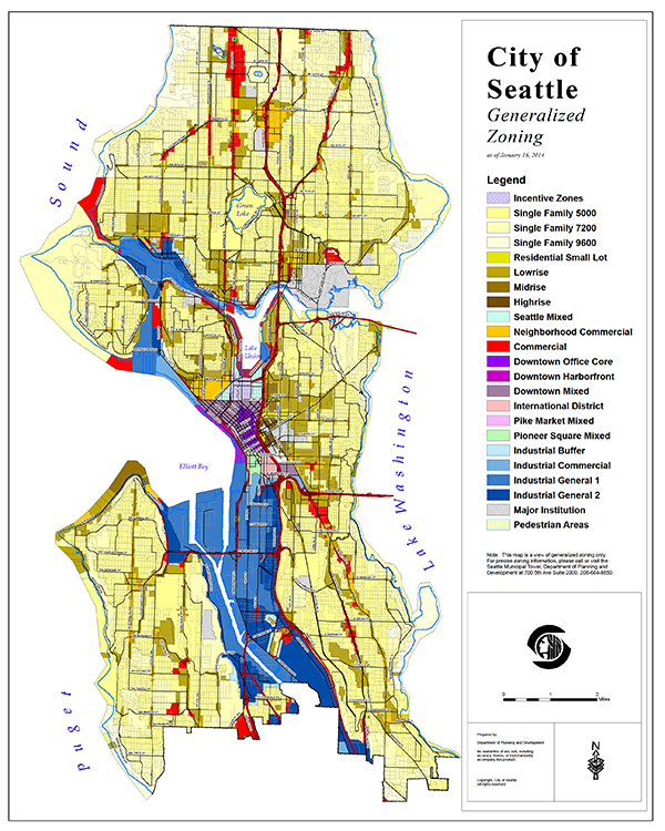
Thanks to **Deb Eddy**for sharing this map she found from the city’s Planning dept web site, which shows the zoning for all parts of Seattle, not just those with L1-3 and MR zoning. All that light yellow and white is single-family:


4 comments
Archived from the original site. Commenting is closed.
A reader named Nick Welch was unable to post in the comments here, so I'm reproducing his comment from email here:<br /><br />"Two brief thoughts. First, though it's usually displayed as a map it can be misleading to consider zoning by geographic area. Higher density areas inherently contain more people and therefore a larger share of the total population. But a cursory look at the map just emphasizes the idea that single-family zones are something like 95% of Seattle.<br /><br />Second, I strongly believe Seattle needs more housing to meet demand and preserve affordability. But it should (and will) occur mostly in urban villages near good transit. Much of the white and light yellow above is irrelevant to that. Suggesting that those areas impede affordability and need to be upzoned might serve only to encourage resistance from homeowners towards our goals."
And my response:<br /><br />Based on the second map\, I think single-family homes are probably closer to 70-80% of the total geographic area, but maybe approaching 90% of total residential area. Someone on Facebook actually noted that there are roughly equal numbers of single-family units and multifamily units in Seattle (140,000 each), so we're fitting probably a little less than half of our total population on that 10-15% of residential area in the city, and with 10,000 units being built every year that should change pretty rapidly.<br /><br />And I agree that most new building should (and will) occur in urban villages, but I'm not sure our urban villages should be forever unchanged. It's relatively easy to improve service to new areas with a few new routes with good headways if the population density warrants it, and allowing more development in some single-family neighborhoods would actually be likely to push up property values, which would benefit homeowners in the area. It might cause them to want to move, yes, but development has that effect on some people no matter where you do it -- at least in single-family neighborhoods you've mostly got homeowners that can actually capture the financial upside, unlike in urban villages where renters just have to deal with higher rents. (Since we waited til the market was really hot to start really pushing new development, prices went up pretty significantly while supply caught up, and those prices are likely to only stabilize in my opinion, not drop.)<br /><br />On the political issue, I do think it's a valid point and worthy of consideration, but I also think that just because it's politically toxic doesn't mean it's wrong. Lots of things are done (or not done) because of politics -- things that most people agree is bad from a rational point of view but those who benefit feel very strongly about, like parking or the mortgage interest tax deduction, for example. But just like with those issues starting to come up for discussion more and more, just because something is politically problematic now doesn't mean it always will be. If no one's even making the case for change, though, it's a sure thing that nothing will ever will.
Why in the world aren't the street fronts along Phinney/Greenwood between 64th and 75th and Roosevelt between 80th and 95th mid-to-high rise? These are ridgetops and would block no one's views. It towers were "checkerboarded" like they are in Vancouver there hundreds of new "view" properties would be created at the stroke of a pen. <br /><br />Yes, there are some shadow concerns but especially Phinney Ridge is so steep and the properties on its flanks sufficiently treed that existing shadows limit sun to half a day anyway. Slender towers might decrease some properties' exposure by 10% or so. <br />
Why in the world aren't the street fronts along Phinney/Greenwood between 64th and 75th and Roosevelt between 80th and 95th mid-to-high rise? These are ridgetops and would block no one's views. It towers were "checkerboarded" like they are in Vancouver there hundreds of new "view" properties would be created at the stroke of a pen. <br /><br />Yes, there are some shadow concerns but especially Phinney Ridge is so steep and the properties on its flanks sufficiently treed that existing shadows limit sun to half a day anyway. Slender towers might decrease some properties' exposure by 10% or so. <br />